Application of Innovative Digital Technologies in Urban Flood Risk Management
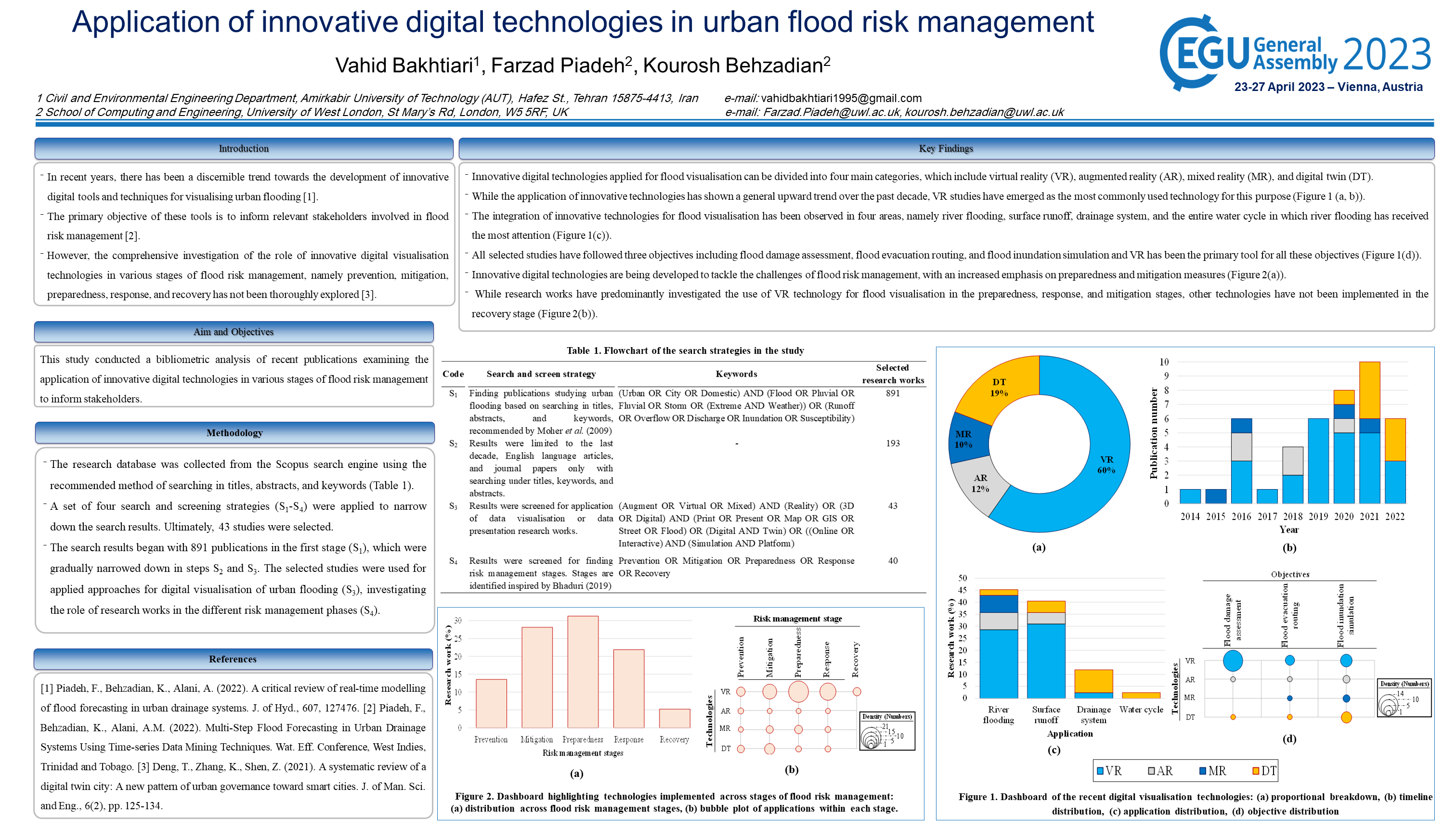
Climate change can lead to several devastating hazards, including extreme rainfall and alteration of precipitation patterns that both contribute to more urban floods and various repercussions on urban life and infrastructure [1]. The establishment of risk management strategies along with engaging involved parties, i.e., authorities and publics, has become an integral part of mitigating strategies for growing urban flood risk [2]. These control measures have undergone several principal transformations in recent years particularly due to development of the real-time early warning of flood forecasting systems associated with digital innovative technologies such as virtual reality (VR), augmented reality (AR), and digital twin (DT). These technologies have been widely used for not only virtually real-time representation of formation and development of urban flooding but also raising stakeholder knowledge and awareness regarding the consequences of flood risk [3,4]. In this research work, the application of digital innovative technologies in the digital visualisation of urban floods and increasing stakeholder awareness has been investigated. To begin with, VR has been widely used to model pluvial floods by creating a simulated artificial 3D environment that allows users to explore and interact with virtual surroundings. AR has been implemented through the development of mobile apps that enables the user to investigate the possibility of a flood. DT commencing an efficient flood risk communication tool to provide the user with information about the current condition, potential risks, and flood-prone areas that are integrated into the complex real-time digital system made up of numerous sensors, logic devices, and predictive functions in urban areas. The results of investigation show while conventional technologies have often concentrated on authorities, the above innovative technologies have shifted their focus to local authorities and public. VR has been comprehensively employed to engage them in risk control management through allowing the users to interact with the system under risks. AR is mainly utilised to serve the public through installed software on their phones and investigating flood-prone areas. The focus of DT has been on involving authorities and operators to understand the real-time information about flood hydraulics and function of urban system and components. Despite the extensive capabilities, DT has yet to be properly taken into account and, if properly presented, can be effective in raising public awareness especially because of its significant abilities in the virtual representation of interactions within the system.
-
picture_as_pdf - EGU23-4143-print.pdf
-
subject - Published Version
-

- Available under Creative Commons: BY 4.0